ShopDreamUp AI ArtDreamUp
Deviation Actions
Ruby Draakonian
Woah! Your getting into some juicy content! There's some really cool things in here >.>
$25/month


Suggested Deviants


Suggested Collections


You Might Like…


Featured in Groups


Description
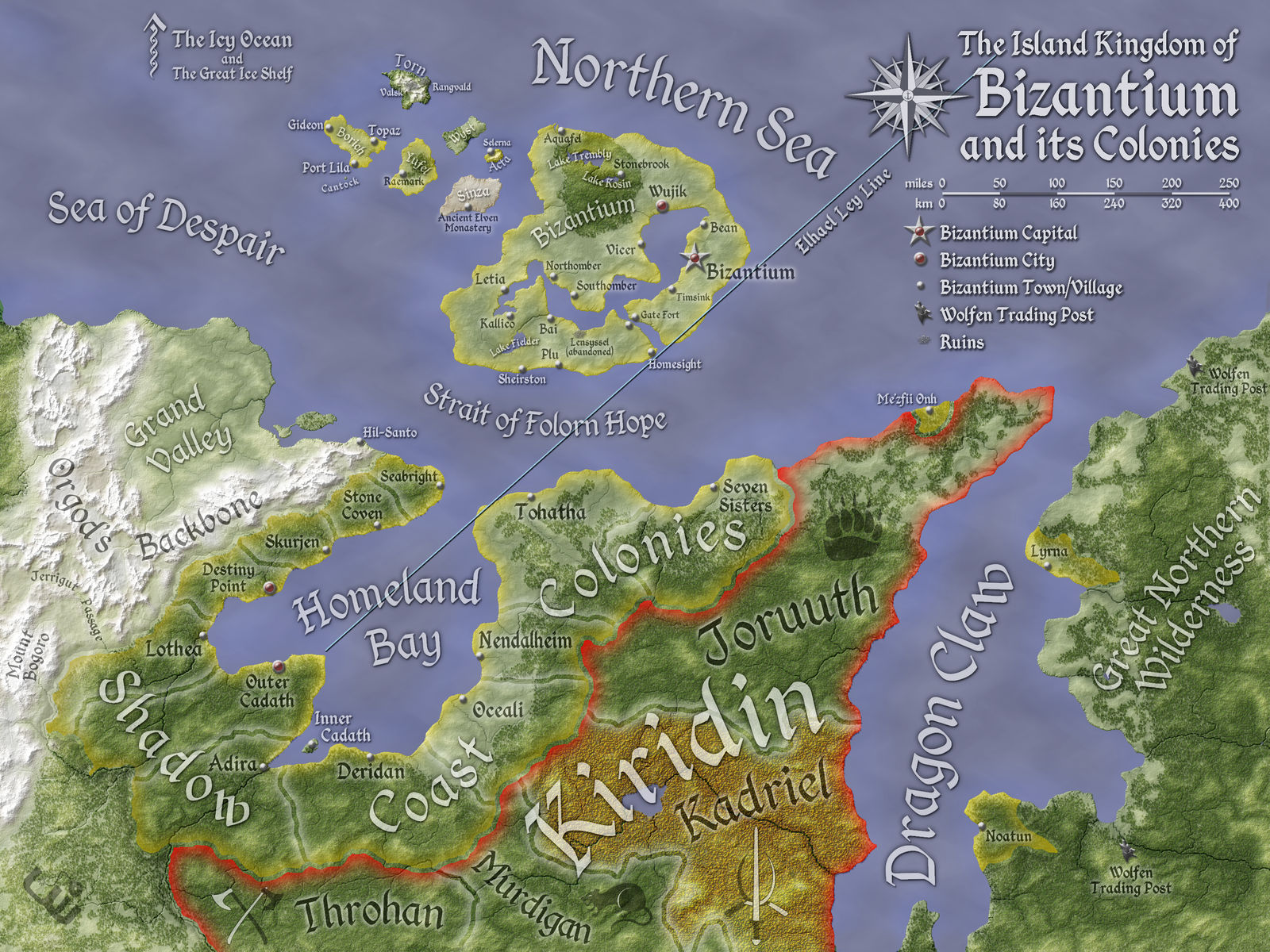
A greyscale version of this map appears in the Palladium Fantasy RPG book, Bizantium and the Northern Isles, available now. A free sneak peek is available here. The first volume to come out for this game line in several years, this book explores the extreme north of the world. This map focuses on the human kingdom of Bizantium, but it also includes elements from several other Palladium Fantasy sourcebooks. My intent was to include all the published information I could to provide a common frame of reference for players and Game Masters.
This color version includes a few additional features not included in the greyscale map. Most notably, it includes forests. I've been doing some experimentation with drawing woods, and this map posed a unique challenge: the barbarian province of Kadriel, a land of eternal autumn, where the leaves are always bright yellow and red (another new feature for this map). Finally, the borders are rendered in color, so all of Byzantium's territories are marked in gold, while the barbarians of Kiridin have their turf marked in red. Since the Wolfen Empire only kind-of has a presence in this region, I didn't put in a border for them.
This version (and the original greyscale) also have a ley line marked that is not mentioned in the book, and is not included in the final, published version of the map. Having read through most of the book, it seems there are actually quite a few ley lines on this map, and including them all would have made the map too messy, so it was probably a good editorial decision to remove it.
Bizantium and the Northern Isles is published by Palladium Books for the Palladium Fantasy pen & paper RPG line. Glen Evans is the lead author, and Kevin Siembieda and Matthew Clements contributed as co-authors. The visionary Chuck Walton is the cover artist for this book, and he is contributing a number of impressive interior sketches.
I created this map primarily in GIMP, with the river and erosion effects coming from WILBUR. The compass rose, labels, and icons were designed in Inkscape. The major geographic features are derived from a composite of several maps published in half a dozen Palladium Fantasy RPG books and a couple of sketches provided to me by Palladium Books. The font for the labels is Kingthings Calligraphica 2. The arrow in the upper-left corner is an adaptation of some letters from Kingthings Flourishes.
I also borrowed a bit from one of my first maps: Kiridin. The scope of the two maps overlap in many areas.
My thanks to Wayne Smith at Palladium Books for providing continuity checks with existing published material and ensuring that this is the most canon-accurate map we could put together.
Also, special thanks to Arsheesh; the techniques I used for fitting labels, making icons, and defining topography are adaptations of his tutorials.
Image size
3000x2250px 9.09 MB
© 2015 - 2024 Will-Erwin
Comments15
Join the community to add your comment. Already a deviant? Log In
This is so cool! ")
And thank you for the Llama, btw!
And thank you for the Llama, btw!